Efficient Accumulation, Analysis and Visualisation of Full-Waveform LiDAR in a Volumetric Representation with Applications to Forestry - Doctor of Engineering (EngD)
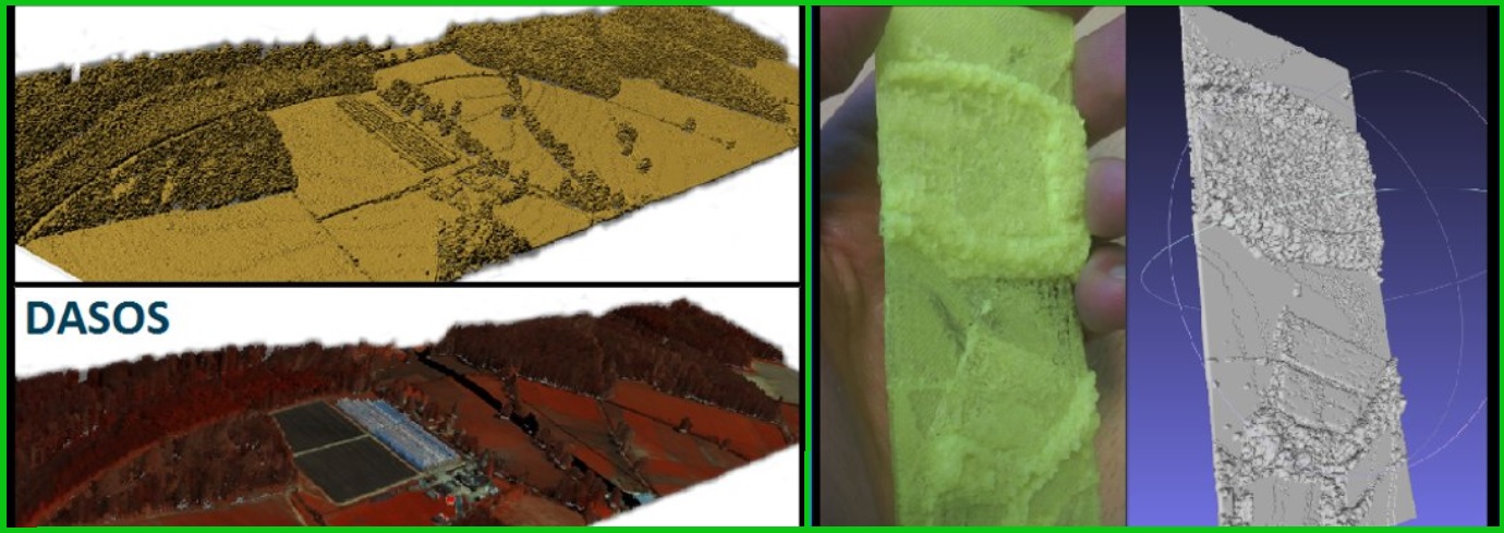
Full-waveform (FW) Light Detection and Ranging (LiDAR) – 3D laser scanning data, usually acquired from aircrafts - is a particularly useful source of information in forestry since it samples data between tree branches, but compared to discrete LiDAR, there are very few researchers exploiting this due to the increased complexity. DASOS, an open source program, was developed, along with this thesis, to improve the adoption of FW LiDAR (DASOS available at: https://github.com/Art-n-MathS/DASOS ). DASOS uses voxelisation (a rasterisation process) for interpreting both discrete and FW LiDAR data and this approach is fundamentally different from state-of-art tools.
There are three key features of DASOS, reflecting the key contributions of this thesis: Firstly, visualisation of a forest to improve field work planning. Polygonal meshes are generated using DASOS, by extracting an iso-surface from the voxelised data. Additionally, six data structures are tested for optimising iso-surface extraction. A new category of data structured named "Integral Trees" was proposed. "Integral Volumes" was the fastest during polygonisation but it used the most RAM (paper: https://www.mdpi.com/2072-4292/13/4/559). This work was acknowledged as a distinguish contribution by Ladies of Landsat and was included in Most Notable articles of the Remote Sensing journal. Secondly, the FW LiDAR data were efficiently aligned with hyperspectral imagery using a geo-spatial representation stored within a hashed table with buckets of points. The outputs of DASOS are coloured polygonal meshes, which improves the visual output, and aligned metrics from the FW LiDAR and hyperspectral imagery. The metrics are used for generating tree coverage maps and it is demonstrated that the increased amount of information improves classification (paper: http://dx.doi.org/10.5194/isprsarchives-XL-7-W3-1257-2015 ). The last feature is the extraction of feature vectors that characterise objects, such as trees, in 3D. This is used for detecting dead standing Eucalypt trees in a native Australian forest for managing biodiversity without tree delineation. A random forest classifier, a weighted-distance KNN algorithm and a seed growth algorithm are used to predict positions of dead trees. Improvements in the results from increasing numbers of training samples was prevented due to the noise in the field data. It is nevertheless demonstrated that forest health assessment without tree delineation is possible. Cleaner training samples would have improved prediction (paper: https://www.sciencedirect.com/science/article/pii/S0303243418300485).

Related Publications
2023
- TREE SPECIES CLASSIFICATION IN A COMPLEX BRAZILIAN TROPICAL FOREST USING HYPERSPECTRAL AND LIDAR DATA
R. P. Martins-Neto, A. M. G. Tommaselli, N. N. Imai, E. Honkavaara, M. Miltiadou, E. A. S. Moriya, H. C. David Forests
- AI APPLICATIONS IN FOREST MONITORING NEED REMOTE SENSING BENCHMARK DATASETS
E. R. Lines, M. Allen, C. Cabo, K. Calders, A. Debus, S. WD Grieve, M. Miltiadou, A. Noach, H. JF Owen, S. Puliti 2022 IEEE International Conference on Big Data
2021
- A COMPARATIVE STUDY ABOUT DATA STRUCTURES USED FOR EFFICIENT MANAGEMENT OF VOXELISED FULL-WAVEFORM AIRBORNE LIDAR DATA DURING 3D POLYGONAL MODEL CREATION
M. Miltiadou, N. D. F. Campbell , D. Cosker, M. G. Grant Remote Sensing
- IDENTIFICATION OF SIGNIFICATIVE LIDAR METRICS AND COMPARISON OF MACHINE LEARNING APPROACHES FOR ESTIMATING STAND AND DIVERSITY VARIABLES IN HETEROGENEOUS BRAZILIAN ATLNATIC FOREST
R.P. Martins-Neto,A.M.G. Tommaselli, N.N. Imai, H.C. David, M. Miltiadou, and E. Honkavaara Remote Sensing
2020
- DETECTING DEAD STANDING EYCALYPT TREES FROM VOXELISED FULL-WAVEFROM LIDAR USING MULTI-SCALE 3D-WINDOWS FOR TACKLING HEIGHT AND SIZE VARIATIONS
M. Miltiadou, A. Agapiou, S. Gonzalez Aracil, D. G. Hadjimitsis Forests
2019
- OPEN SOURCE SOFTWARE DASOS: EFFICIENT ACCUMULATION, ANALYSIS, AND VISUALISATION OF FULL-WAVEFORM LIDAR
M. Miltiadou, M. G. Grant, N.D.F. Campbell, M. Warren, D. Clewley, D. G. Hadjimitsis SPIE Library, Seventh International Conference on Remote Sensing and Geoinformation of the Environment (RSCy2019)
2018
- DETECTION OF DEAD STANDING EUCALYPTUS CAMALDULENSIS WITHOUT TREE DELINEATION FOR MANAGING BIODIVERSITY IN NATIVE AUSTRALIAN FOREST
M. Miltiadou, M. G. Grant, N.D.F. Campbell, M. Warren, D. Clewley, D. G. Hadjimitsis International Journal of Applied Earth Observation and Geoinformation
2017
2016
- IMPROVING AND OPTIMISING VISUALISATIONS OF FULL-WAVEFORM LIDAR DATA
M. Miltiadou, NDF Campbell, M Brown, D Cosker, Micheal Grant,Proceedings of the conferece on Computer Graphics & Visual Computing
2015
- ALIGNMENT OF HYPERSPECTRAL IMAGERY AND FULL-WAVEFORM LIDAR DATA FOR VISUALISATION AND CLASSIFICATION PURPOSES
M. Miltiadou, M.A. Warren, M. Grant, M. Brown, The International Archives of Photogrammetry, Remote Sensing and Spatial Information Sciences